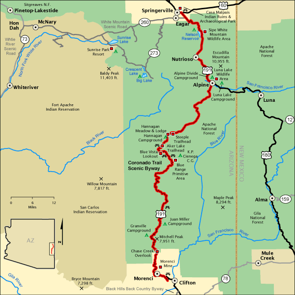
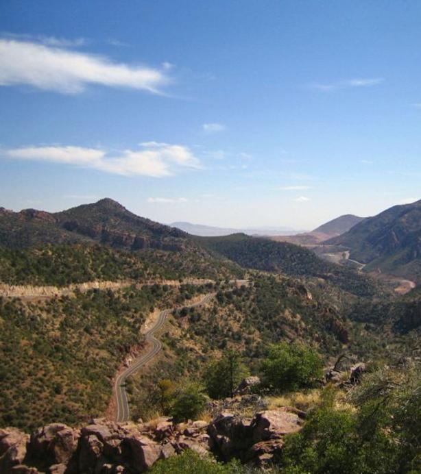
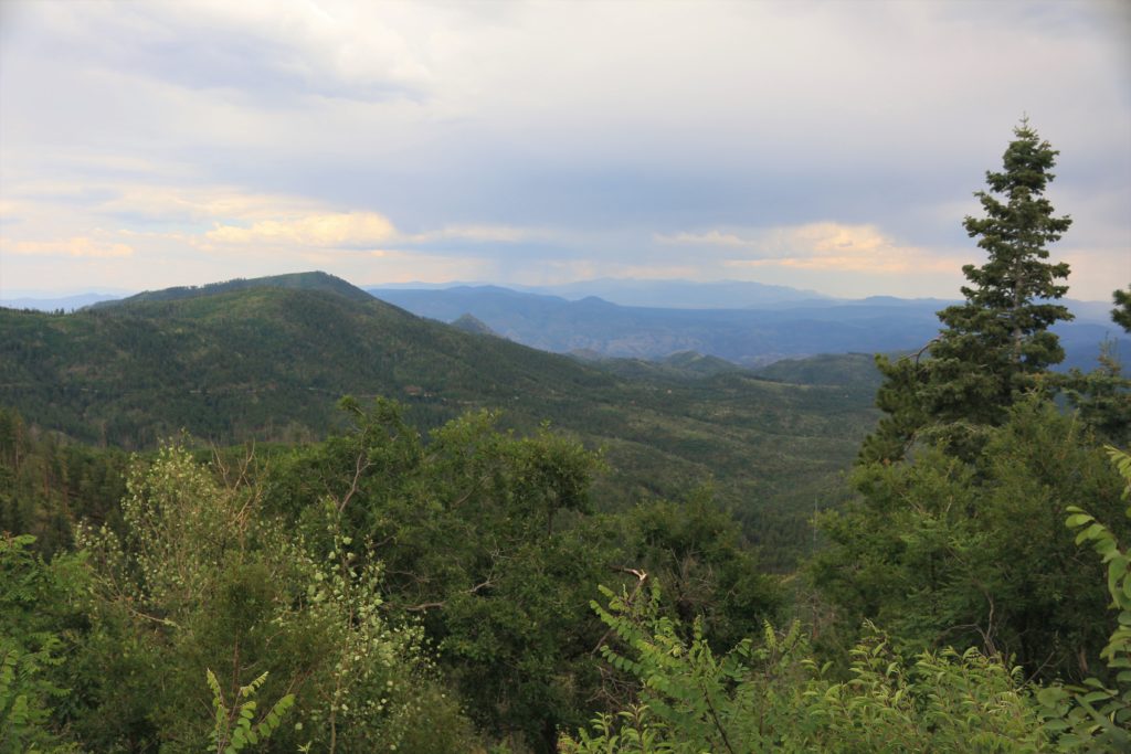
“The Mountain Paradise of Arizona”, Greenlee County is a remarkable vacation land awaiting “exploration”. The Coronado Trail itself is one of the world’s foremost scenic highways. Traveling its full route through Greenlee County can be accomplished with less than a 100 mile “journey”. Encompassing most of the County, this Apache-Sitgreaves National Forest “expedition” begins with the Coronado Trail and the southern towns extending along the rugged regions of the magnificent Mogollon Rim, Blue Range Primitive Area and Bear Wallow in the White Mountains of Arizona. Scenic landscapes range from high desert areas to Alpine-like vistas with a highpoint of 9,355 feet at Blue Peak. Rivers, trout streams, ponds and an amazing progression of vegetation at different elevations provide a great variety of year-round recreational activities. Truly a “paradise” with views unmatched anywhere!
>>
On the Coronado Trail (US 191)
Chase Creek Overlook, located on US 191 at MP 176.5 for a southwestern viewpoint of the canyon, is an amazing viewpoint showing the quick change from high desert vistas and mined mountainsides to tree-lined mountain ranges punctuated with rock formations. Chase Creek, which flows periodically, originally entered the San Francisco River to the east, but the mine has interrupted its flow. It was then piped through the Morenci Mine to the west.
Cherry Lodge Picnic Site. The lodge was in operation beginning in 1929 and is so named because of the wild cherry trees growing nearby. Popular for Sunday dinners in the 1940’s, this lodge was victim to a devastating fire some years after. Today this site offers a wonderful stopping point to stretch or picnic while traveling the Coronado Trail. Located on the west side of US 191 near MP 178.
Granville Recreation Area. Granville Road (FR 506). East off the Coronado Trail (US 191) near MP 178, Granville Recreation Area is known for its beautiful scenery of spring flowers, summer shade tree canopies, and amazing scenic views of the changing colors of fall. With a centrally located campground and surrounding trail system this recreation area conveniently becomes a long stay adventurer’s base camp. Trails of this area offer connections to Sardine Saddle and HL Saddle. Trailer parking and public corrals are available within the campground located at the north end. RV hook-ups are not available and visitors should be prepared with plenty of water.
Granville Campground, located within the Granville Recreation area, is the first developed camping and rest area heading northbound on the Coronado Trail that travelers will encounter. Summer Cabin Community of Granville, located behind the campground, sprang up on the Coronado Trail and was a source of timber for the mines to the south. Privately owned cabins speak of another era when miners sent their families north during warm weather. Granville is now a popular place for Greenlee County and other desert residents to enjoy summer cabin living within its cool canyon location.
Sardine Saddle Picnic Area and Trailhead Parking, located on east side of US 191, MP 181,is a wonderful site for use as a rest stop or picnic area. It’s also used as a parking lot for area trails and overnight camping is permitted.
Eagle Creek Recreation Area. Located west off of US 191 at MP 188. Take Eagle Creek Road (FR 217) 15 miles to the Village of Eagle, a community in Upper Eagle Creek Valley. It was the chosen site of homesteaders in the mid-1800s.
This remote but accessible village welcomes its visitors to enjoy the country lifestyle visually depicted by Eagle Creek’s many ranches along its banks. Upper Eagle Creek Valley was the inspiration for many of the paintings of western artist Tim Cox. Pictures and words alone cannot describe the beauty of this recreation area. A large variety of wildlife inhabit the area and hunting, camping, hiking, and horseback trail riding are a few of the many outdoor activities to enjoy.
Eagle Schoolhouse is a one-room historic building that graces sightseers with the feeling of being a part of “The Old West”. Northwest on Eagle Creek Road (FR 217), turn west on Eagle School Road (FR 217E).
Honeymoon Campground and Trailhead, 22 miles on FR 217, is located next to Eagle
Creek. It is ideal during the months of May through September for camping,
picnicking, and wildlife viewing. It is shaded by sycamore, cottonwood, pinon,
and juniper trees. Quiet seclusion. The fee-free campsites offer restroom
facilities, picnic tables, and two standing grill sites. This site is prepared for trailer parking,
but there are no hookups.
Upper Juan Miller Picnic Area and Campground is east off the Coronado Trail at MP 188.8. Take Juan Miller Road (FR 475) less than 2.25 miles to Southbound FR 475B. This facility provides its visitors with water-play and wildlife viewing. This fee-free site offers picnic tables and restroom facilities. Camping can be enjoyed year round, unless the access road is closed by snow, but it is not suitable for trailer or RV travel to enter this campground.
Lower Juan Miller Campground is also east off US 191 at MP 188.8 and is less than 2 miles on FR 475 to Southbound FR 475A. It is shaded by large Gambel oak and sycamore trees like the Upper Juan Miller site, though this lower site is less visited. Camping or horse trailers can be brought to the site easily. Picnic table and grill amenities are available in each site, and the campground has restroom facilities. Enjoyed year-round, unless access road is closed by snow.
Rose Peak Lookout Tower (near the Rose Peak Picnic Area and Trailhead) has long served the Forest Service to spot and monitor fires at an elevation of 8,700 feet. If manned during the fire season, visitors may be invited to a glass-enclosed tower room for a stunning view of the mountains. Take the Rose Peak Lookout (LO) Road (FR 501) southeast off of US 191 in between MP 207 & 208.
Sheep Saddle Picnic Site also known as Engineer Springs area, was the location of the Civilian Conservation Corps (CCC) construction camp which housed the men who built the first 33 miles of the Coronado Trail. In 1929 Sheep Saddle was the site of a proposed sawmill. This picnic site and rest stop is a loop pull-off and includes trailhead parking and restroom facilities.
Hagen RV Pullout (FR 8329), located on the west side of Coronado Trail (US 191) between MP 215 and 216, is a RV campground that offers public corrals, picnic tables, grills and restroom facilities.
Reservoir/Pond Loop Road (Docent) FR 8497, located west off of US 191 at MP 217, is a primitive campground located northeast of Rattlesnake Lake.
Strayhorse Recreation Area is west off Coronado Trail (US 191) at MP 220. A Forest Service Administration Site on FR 589 is on the west side of the highway.
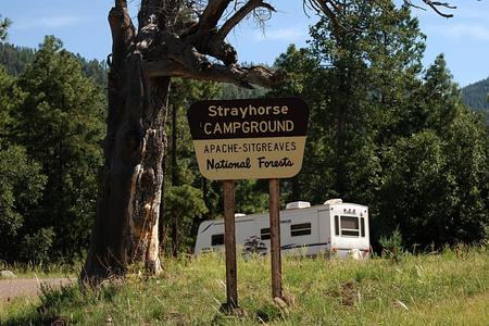
Strayhorse Campground and Trailhead is a fee-free campground with sites on both sides of the highway. The large ponderosa pine and Gambel oak offer shaded picnicking and camping, plus some shelter for a horse, motorcycle, bicycles, etc. There are public horse corrals and ample parking for trailers. With this location just six miles below the Mogollon Rim, the activity possibilities are endless. Restroom facilities, horse corral, picnic tables, prepared fire rings and standing grills.
Arrow Tree, located on US 191 near MP 223, is located on a down-slope from the road. The challenge of hitting this tree with an arrow seems to have begun in the 1980’s by local hunters. Since the 1920’s local hunters have boasted of hunting bear, lion and wolf in addition to deer and elk.
Blue Vista Overlook Picnic Site, located south of US 191 at MP 225 (FR 578), loops into this rest area and its three-point view. Meet fellow Coronado Trail explorers from all over the globe at this not-to-be-missed stop along the Trail.
Blue Lookout Road (FR 184). Southeast off of US 191 just after MP 225.
Rim Trails Road (FR 54D). Northeast Trailhead west off the Coronado Trail (US 191) at MP 226.
Rim Trailhead (FR 54). South Bear Wallow Wilderness Area. West off the Coronado Trail (US 191) at MP 226.
Reno (FR 25) and Black River (Jct. FR 24). Bear Wallow Wilderness Area. West off US 191 in between MP 226 & 227.
KP Cienega Campground is east off the Coronado Trail just south of MP 227 on KP Cienega Road (FR 55). This is a wonderful, centrally-located campground with an array of amenities and outdoor adventure possibilities. The nearby rim trails offer panoramic views of the entire Eagle Creek recreation area below the rim of the Colorado Plateau. Bear Wallow wilderness trails allow hikers and horseback riders to camp, fish for native Apache trout, or enjoy the many wildlife viewing opportunities of this wilderness riparian area. Take a “gone fishing” day trip to Aker Lake or to one of the many creeks in the area — all abundant with trout and many other anglers’ preferred choices. Campground amenities include picnic tables, fire rings with cooking grills and restroom facilities. Free tent/trailer camping or picnicking is available at this location.
Aker Lake Fishing Site is west off US 191 between MP 228 & 229 along Aker Lake Loop Road (FR 8312). Take the northern entrance of this forest loop road for the shortest route to the lake. This lake is one of many quiet, out-of-the-way getaways found in Greenlee County and the Apache-Sitgreaves National Forest. It is ideal for fly and lure anglers to catch and release trout and grayling. Primitive camping, hiking and a beautiful drive through the Alpine meadow and evergreen forest lands of this area can be enjoyed by all. Elk and other wildlife are abundant in the area.
Hannagan Meadow Recreation Area possesses something to pique everyone’s interest. One can satisfy a sense of adventure, or just relax in an atmosphere of rugged, untamed lands. Enjoy nature and be free from the binding chains of technology. An amazing vacation destination gem, Hannagan Meadow comes complete with historic lodge (Hannagan Meadow Lodge), rustic campgrounds, quiet cabin rentals, access to the Blue Range Primitive Area, breathtaking views from the edge of the Mogollon Rim, hunting, fishing, and winter trails. This high forest, backcountry jewel-in-the-wild is truly a four-season sporting paradise for a wide range of outdoor pursuits.
Hannagan Campground, at 9,100 ft., and on the west side of the Coronado Trail, US 191, is one of the highest campgrounds in Arizona. High county tree species such as spruce, fir, and aspen shade campsites. This fee-free campground offers prepared campsites for tent/trailer camping with picnic tables, fire rings, restrooms facilities and drinking water (May-September). Though many areas of the forest can be enjoyed year-round, this campsite is best visited June through September. Campsites are accessible to 16 foot or smaller trailers and RV’s, though no hookups are available at this site.
Access to an excellent network of hike/bike/ride trails is available thoughout this high forest. Nearby access trails bring travelers to the Blue Range Primitive Area for even more backcountry to explore by way of hiking or horseback riding. Close proximity to the designated primitive wilderness areas and backcounty roads boasts an array of opportunities for even more scenic drives and wildlife viewing. These many means of traveling though the Apache-Sitgreaves National Forest all allow visitors to be astonished by the drastic landscape change from Alpine forest to high desert and the versatile vegetation in between. Furthermore, this area provides the opportunity to partake in year-round outdoor sport and adventure activities including wintertime’s snowmobiling, cross-country skiing, snow shoeing and sledding fun. When they say it’s cool up here — they’re not just talking about the weather!
Travel to Sprucedale via FR 24 to Jct. FR 565
Carlton Vista Overlook, located east of US 191 on FR 58 heading toward the community of Blue, it is in the middle of a hairpin turn. It is a great pull-off to stretch and take a moment to take in the southeast vista view of the Red Hills below. Overlook two valleys stretching alongside Red Hill Road and carved by the creeks running through them — Centerfire Creek to the northeast and Bush Creek to the southwest.
Village of Blue. From US 191 turn northbound at the Red Hill Road (FR 567) Junction. Blue is approx. 3 miles north of the intersection of Red Hill Road and FR 281.
Blue Crossing Campground. Traveling from US 191 near Beaverhead, turn onto Red Hill Road (FR 567) and head east 12.1 miles. The campground entrance is to the left (north) right before the river crossing. This campground is located beside the Blue River at 6,200 ft. elevation within this beautiful river valley. Nestled in the middle of the historical rustic ranching community of Blue, AZ, this campground for picnicking and tent/trailer camping offers amenities of picnic tables, prepared fire rings, restroom facilities. Two of the campsites have Adirondack-style shelters. Note: When hauling trailers or traveling by way of RV, use the alternate route on Blue River Road (FR 281) from US 180 just east of Alpine (across from Luna Lake and marked as Apache County 2104).
This fee-free campground is a perfect choice for a peaceful camping experience in a beautiful setting well off the beaten path. It also provides a convenient base camp for anyone seeking to explore the community of Blue or Blue Range Primitive Area via the Tutt Creek Trail #105 and the many trails offered off the Blue River Road (FR 281). Hunting, hiking, horseback riding and nature viewing are just a few of the activities that can be enjoyed during a stay at this site.
Upper Blue Campground is a river valley camping experience located in the northeast corner of Greenlee County, sitting below the high bluffs and next to the Blue River. Traveling from US 191 near Beaverhead, turn onto Red Hill Road (FR 567) and head east 12.2 miles. At the Blue River crossing head northbound on Blue River/Turkey Creek Road (FR 281). The campground entrance is to the left (north) right before the river crossing. This campground for picnicking and tent/trailer camping offers amenities of picnic tables, prepared fire rings, restroom facilities and two campsites have Adirondack-style shelters. Note: If hauling trailers or traveling by way of RV, use the alternate route on Blue River/Turkey Creek Road (FR 281) from US 180 just east of Alpine (across from Luna Lake and marked as Apache County 2104).
Hike to the top of Maness Peak (8,262 ft.) to the southeast, or the 8,129 feet summit of Milligan Peak to the north/northwest. Explore Jackson Box to the south and the historical Fogg Cabin to the north. Midway between the ranching communities of Blue and Whispering Pines, this fee-free campground is a perfect choice for exploring the northern waters of the Blue River Valley and the history it holds. Hunting, hiking, horseback riding and nature viewing are just a few of the activities that can be enjoyed during a visit to this site.
Blue Range Primitive Area (PA) is generally southeast of the Village of Blue. The Blue Range Primitive Area, created in 1933, lies in east-central Arizona between the Coronado Trail National Scenic Byway (US 191) and the New Mexico border. It is named for the Blue River that flows north to south through the center of the area. It is rugged terrain similar to the White Mountain area to the west of the highway and is also a three-season hiking area. Only hiking and horseback riding, non-motorized, non-mechanized transport are allowed within this 173,762 acres of “wild” designated land. The Blue Range PA, is managed similar to a Wilderness Area.
Middle Mountain Wildlife Habitat Area is northeast off US 191 on FR 37, north of Beaverhead. Middle Mountain Wildlife Habitat Area is a gentle to moderately steep southwesterly facing mountain rim area of land that lies between Beaver Creek and Middle Mountain. Early morning and evening should provide wildlife photographers and viewers the best opportunities to view the large herds of deer and elk that have been observed within this reserve-like wildlife habitat. This area is closed to motorized vehicles from August 15th until December 31st. Road closure is especially important for preservation efforts made for all animals populating this habitat area during the hunting season.
The Wild Bunch Recreation Area. Loop Around . . . south on US 180 in NM, leave Alma, NM westbound on C 017, then head NW on C 008. This expedition follows many of the same paths used on the historic Outlaw Trail. This true wild west adventure will bring its travelers to an amazing insight of life on the ranchlands of the southwest — lands renegade outlaws used to hide out in.
Charlie Moore Place was, as told by some, a frequently visited stop by many outlaws. Charlie Moore, an ally to traveling bandits and renegades, was famous for allowing these men to “hold-up” a spell at his ranch. He would tend the wounded and provide food and shelter for weary travelers and their mounts. It has also been mentioned that Charlie made his earnings off the gratitude of these guests as he could not compete with nearby ranches, like the WS Ranch, which were much larger than his own.
Corrals are located at Charlie Moore Place and a designated camp site is located just north called Stateline. This area is extremely difficult to travel after rainfall and trailers are not recommended during the wet seasons. County Road 008 ends at the “Y” intersection with Charlie Moore Ranch Road (C 834) heading southwest to Charlie Moore Place.